Dakota Territory was divided in half – north and south – and statehood for South Dakota became a reality in 1889. In 1890, historian Frederick Jackson Turner declared the ending of the frontier, a psychological, if not factual, milestone the frontier concept continued to influence America’s perception of itself.
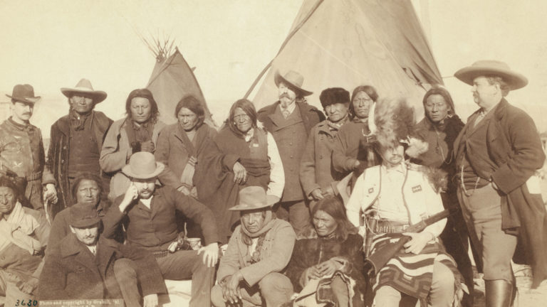
Parts of the Great Sioux Reservation east of the Hills had been opened to settlers in 1889, and the Lakota were placed on six smaller reservations west of the Missouri River. From 1904 to 1911, thousands of additional West River acres were made available in government land lotteries. Homesteaders poured into the state to sign up for the drawings. In the first lottery nearly twenty-five hundred homesteads were available, and over one hundred thousand people signed up. Once notified that they had won, homesteaders crossed the Missouri River to stake claims. Here they learned what the Lakota already knew regarding their 160-acre plots – the land was not well suited to traditional farming. New crops such as alfalfa and winter wheat did the best here. But cattle and sheep still were best suited. Small ranches soon dotted the plains around the eastern slopes of the Black Hills all the way to the Missouri River. Despite intermittent droughts, the rapid rise of population in the West River region continued until about 1915.
The Black Hills entered the twentieth century with a sense of permanence. The following is a fairly typical description of the Black Hills as of 1904.
The Black Hills (from History and Government of South Dakota by G.M. Smith, M.A. and C.M. Young, PH.D – 1904)
“This section lies in the five counties of Fall River, Custer, Pennington, Lawrence, and Meade. It covers an area of about five thousand square miles. Its system of mountains is but an outlier of the Rocky Mountains, and its mineral products and general features are such as are common to that system. There is hardly a mineral of any importance that is not found in greater or less abundance in the Black Hills. The mountains are covered with heavy forests of pine and spruce, whose dark hue, when seen from a distance, caused the Indians to designate them in their own language as the Black Hills. Burr-oak and white elm are found on the foothills and in the valleys. The Indians early knew of the presence of gold in the Hills, but it was not widely known to white men prior to 1874, when an expedition under the command of Lieutenant Colonel George A. Custer visited this region. Prior to this time, the Indians had brought quantities of gold to the trading posts, and this eventually aroused sufficient interest to lead to the exploration of the region, before the whites had any treaty rights therein. The minerals of the Black Hills render it one of the most important parts of the State, and there is ample evidence that the mineral areas have not yet been adequately opened up, and that the output of the mining industry in the future will far surpass anything known in the past.”
As did the rest of the country, the residents of the Black Hills contributed personnel, minerals, food, and support in the war effort during World War I. Cavalry troops and their horses were trained and shipped from Fort Meade and from Fort Robinson, Nebraska.